Over the past few months, I have come up with a few questions about various things with regards to Unit 4 and have been unable to find an answer.
1. I am curious, what does Unit 4 do with Illinois Youth Survey (IYS) responses? This is more of a personal curiosity for me; I don’t think the IYS responses should be public, but I am curious how the response are used by the district and how they inform future decisions.
2. In the timeline provided by Codagami in their RFP response, they collected “user stories” by November 27th. Is Unit 4 at liberty to share those stories? Or can you provide some sense of what “users” have said? Will this information trickle down to the Choice Committee at some point?
3. I have been looking through the RPC presentations (in the context of the Central site), and it is not clear to me that a Traffic Impact Analysis (TIA) has been performed for the sites north of I-74. Curious, do you know if such analysis has been done for the new site? Can the results be shared?
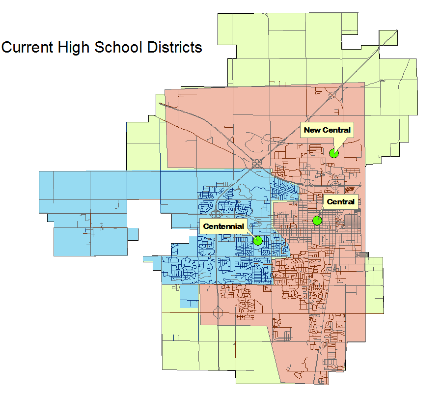
4. I was able to find a PDF that described the current high school attendance boundaries, but I was not able to find a map (I tend to be more of a visual person):
Do you know if a map exists? Or maybe I should ask, can such a map be made public? To reiterate, I am looking for a map of the current high school attendance boundaries. I realize that the district is making plans for redistricting in the near future and thus there are not solid plans for new boundaries yet. Although a ball-park estimate might be helpful. 🙂
—————————————
As an aside, I generated my own map – it looks really rough because, well, it is. 🙂 I am no ArcGIS professional. But at least it helps me get a sense for where the boundaries are. I used the list of streets from the aforementioned attendance boundaries pdf – note that I left some streets off the color-coded section, since this is just a rough hack job. It is not meant to be authoritative nor comprehensive.